Fulra Limestone Fm
Type Locality and Naming
OUTCROP. Named after the village Fulra in the western Kutch. Type section is best exposed in southern flank of Babia Hill, about 1.7 km (or 17.7?) SW of Fulra village in western Kutch. The upper part is also well exposed in the nala to the south of Fulra.. [Original Publication: Biswas, S.K. and Raju, D.S.N. (1971) Note on the rock stratigraphic classification of the Tertiary sediments of Kutch Quart. Jour. Geol. Min. Met. Soc. India.]
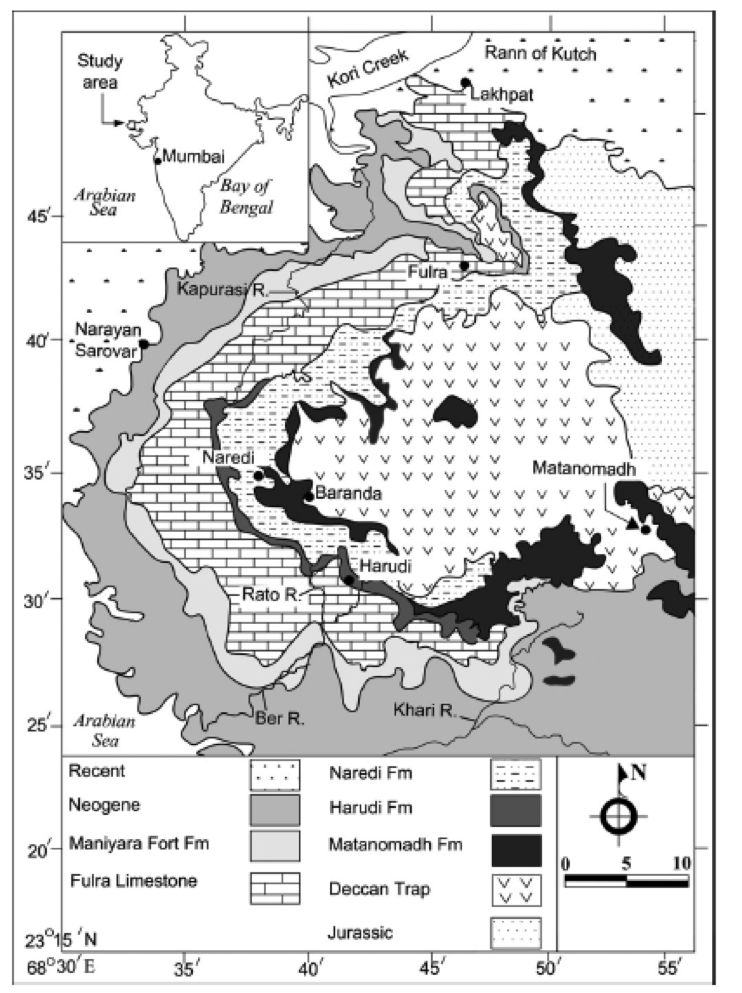
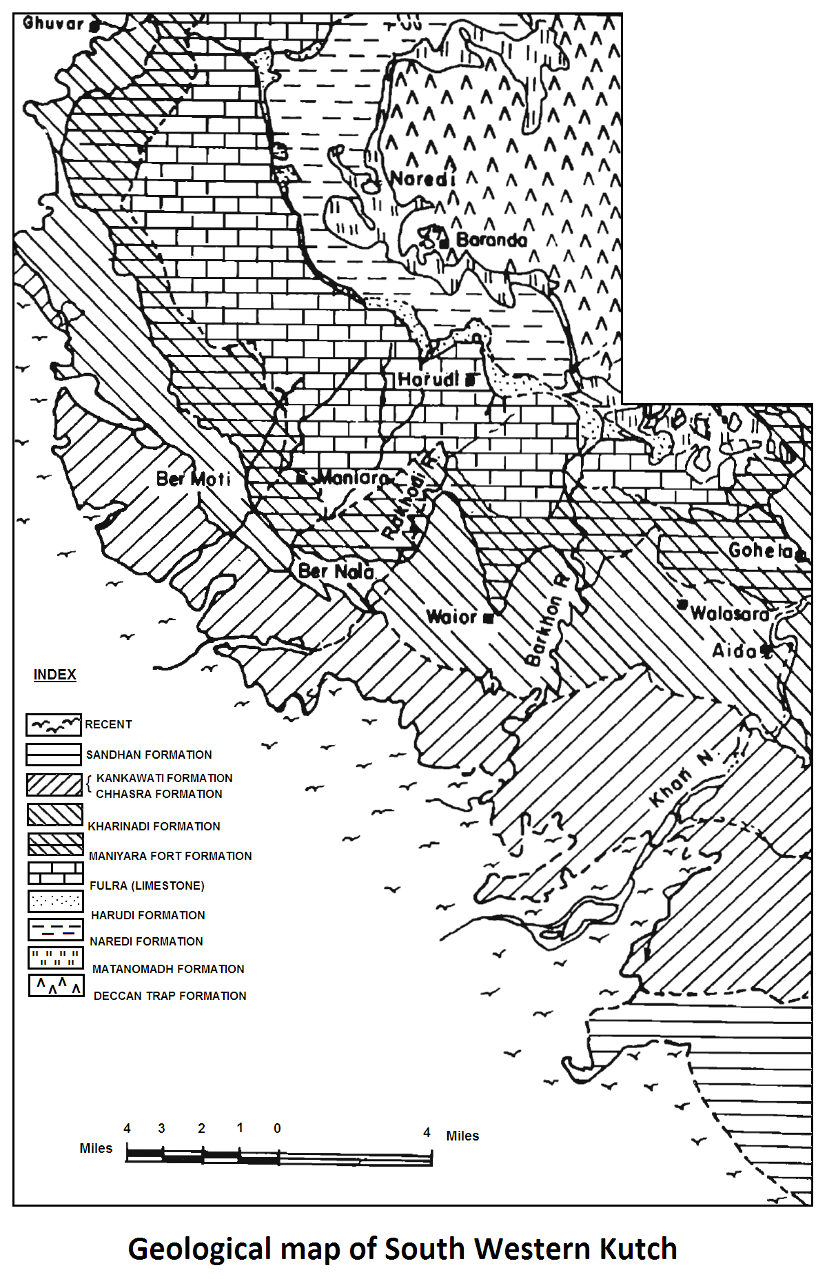
[Figure 1 = Geological Map of Kutch showing the stratotype locality Fulra (map modified after Biswas. 1992).]
Synonyms: Fulra Fm. This formation has earlier been named variously like Nummulitic Group (Wynne, 1872); Kirthar Series (Sen Gupta, 1964; Poddar, 1959; Tewari, 1957). A thick sequence of bedded white foraminiferal limestone overlying the argillaceous formation forms a very distinct litho-unit in the Tertiary succession of Kutch (Source: Pandey and Dave, 1998).
Lithology and Thickness
Limestone. Type section is made up of massive to thickly bedded, white, and buff colored foraminiferal limestone. The limestones are fossiliferous micrites, biomicrites and biomicrosparites that are locally silty (Hardas and Biswas, 1973). It is only 23 m thick in the type section. Maximum thickness of 60m exposed in the Berawali stream section. Thickness of Fulra limestone is more than 400m in the well GK-1-1 and GK-S-1 and GK-36-1.
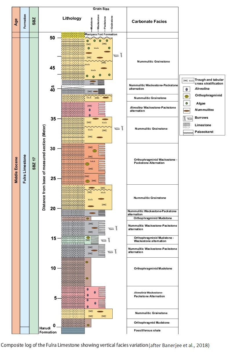
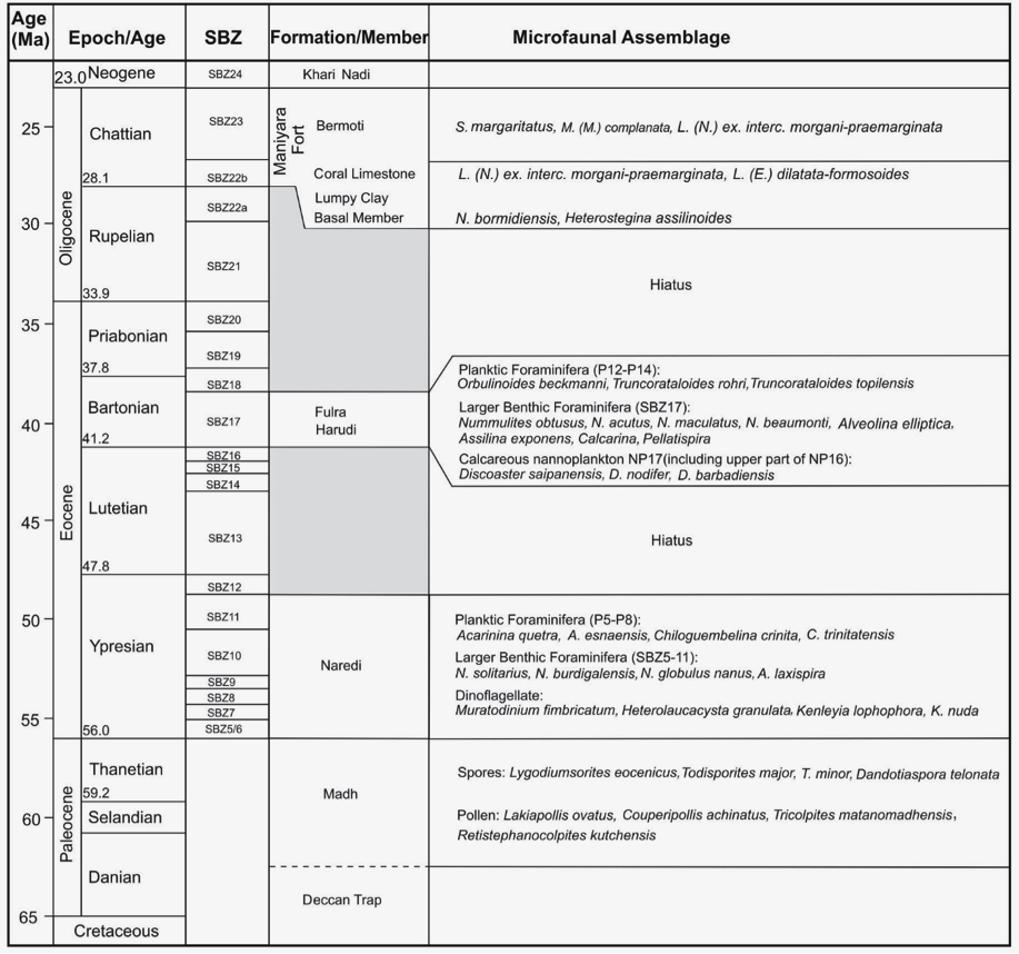
[Figure 0: Lithocolumn of Fulra Limestone Fm (after Banerjee et al., 2018).]
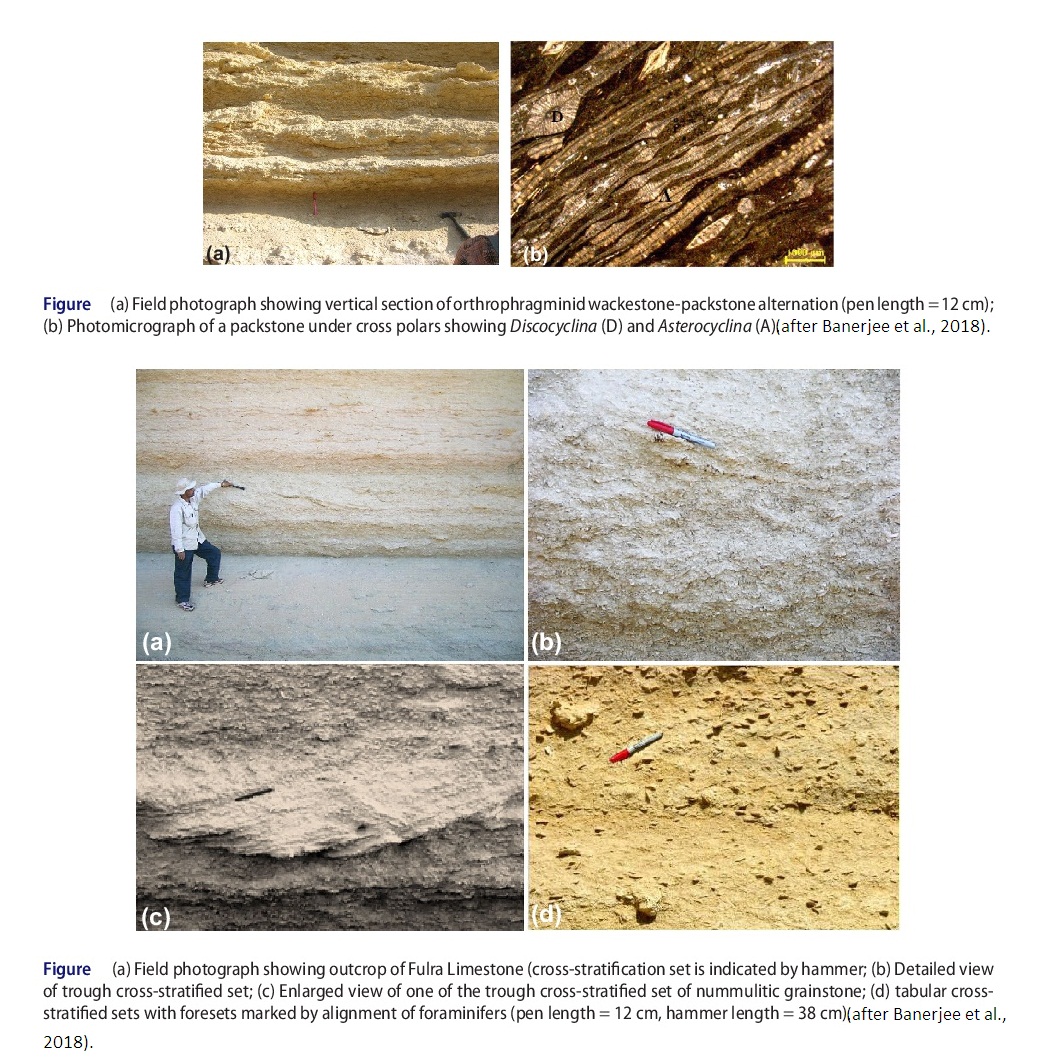
[Figure 1: Field photograph showing outcrop of Fulra Limestone (a-d). (after Banerjee et al., 2018)]
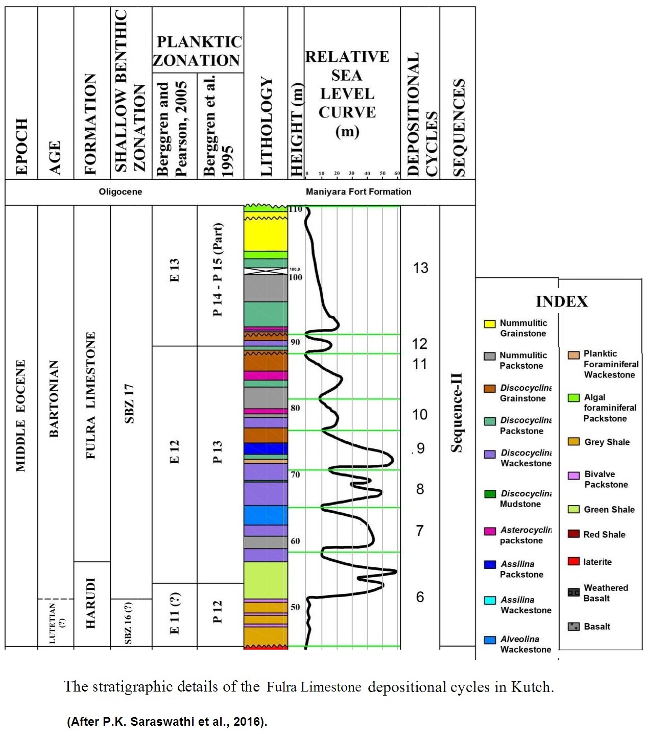
[Figure 2: Composite log of the Fulra Limestone (after Banerjee et al., 2018)]
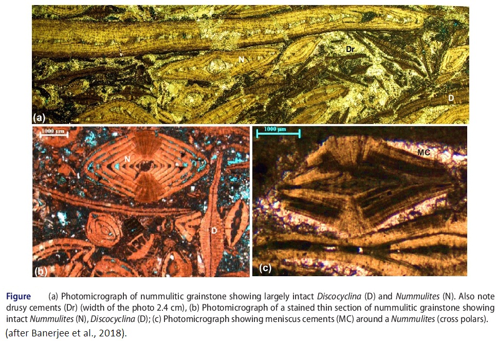
[Figure 3: Photomicrograph of nummulitic grainstone showing largely intact Discocyclina (D) and Nummulitis (N). (a-c) (after Banerjee et al., 2018)]
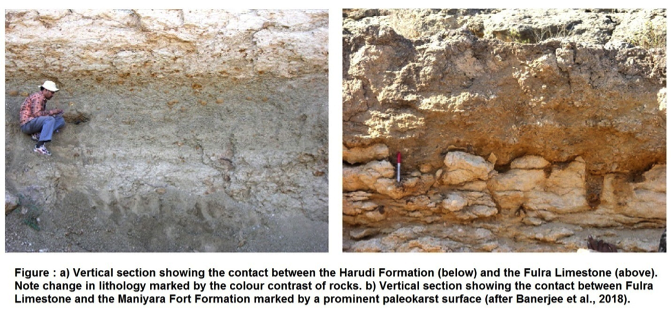
[Figure 4: a)Vertical section showing the contact between the Harudi Formation and Fulra Limestone. b)Vertical section showing the contact between the Fulra Limestone and Maniyara Fort Formation. (after Banerjee et al., 2018)]
[Figure 5: Geological Map of South Western Kutch (after Biswas and Raju, 1973)]
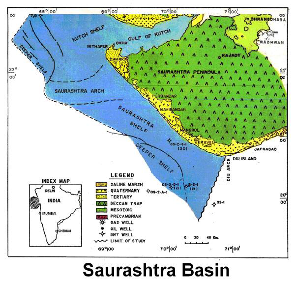
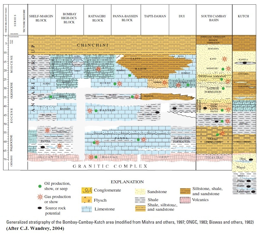
[Figure 6: Generalized Stratigraphy of the Bombay-Cambay-Kutch area (after C.J. Wandrey, 2004)]
Relationships and Distribution
Lower contact
In the Kutch outcrop successions, this formation’s lower contact to the Harudi Fm is the base of its massive limestone. In the Kutch Subsurface, the lower boundary is marked by the sharp change in resistivity from serrated character of the underlying Jakhau Fm and 15-20m thick clastic bed in the wells SP-1-1 and GK-1-1, GK-33A and is unconformable but locally disconformable showing cut and fill structures and bioturbation. Lower boundary is conformable with the Belapur Fm in the Saurashtra Basin.
[Figure: Contacts: (a) Vertical section showing the contact between the Harudi Fm (below) and the Fulra Limestone Fm (above). Note change in lithology marked by the color contrast of rock. (b) Vertical section showing the contact between the Fulra Limestone Fm (below) and the Maniyara Fort Fm (above) marked by a prominent paleokarst surface (after Banerjee et al., 2018).]
Upper contact
In the Kutch and Saurashtra basins offshore, the Fulra Limestone Fm is unconformably overlain by the Tuna Fm Limestone, and the boundary coincides with last occurrence of Pellatispira. A local upper boundary of the formation in Kutch outcrops with the Maniyara Fort Fm is unconformable. A sharp contact separates the two formations in Lakhpat (23.8°N, 68.7°E) where the species of Alveolina, Discocyclina and Nummulites of the Fulra Limestone disappear and the reticulate N. fichteli of the Maniyara Fort Fm appears.
Regional extent
It increases towards west in Kutch offshore and completely sails out over Diu Arch where it is called Belapur Fm and Diu Fm
GeoJSON
Fossils
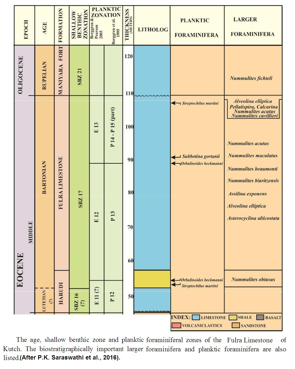
Two zones, namely Orbulinoides beckmanni Zone in the lower part and Truncorotaloides rohri zone in the upper part were identified in Kutch Basin. The larger foraminifera belong to Discocyclina sowerbii Zone in the lower part and Fasciolites ellipticus zone in the upper part.
The planktic foraminifera fauna of the Fulra Limestone are well documented by Mohan and Soodan (1970) and Samanta (1970). They referred it to Orbulinoides beckmanni and Truncorotaloides rohri zones. In the revised scheme of Berggren and Pearson (2005), it corresponds to the zones E12 and E13. The formation contains a number of species of larger foraminifera. It includes, Alveolina elliptica, Assilina exponens, Asterocyclina alticostata, Calcarina sp., Discocyclina dispansa, D. sowerbyi, Nummulites acutus, N. beaumonti, N. biarritzensis, N. discorbinus, and N. maculatus. Considering the ranges of these species given by Serra Kiel et al. (1998) and Shukla (2008), the assemblage is referred to SBZ17. Rai (1997) referred Harudi Formation and Fulra Limestone to emended calcareous nannoplankton zone NP 17 (including NP 17 and part of NP 16 zones of Martini, 1971).
The contact between the Fulra Limestone and the overlying Maniyara Fort Fm is variously manifested in the field. A sharp contact separates the two formations in Lakhpat (23.8° N, 68.7° E) where the species of Alveolina, Discocyclina and Nummulites of the Fulra Limestone disappear and the reticulate Nummulites fichteli of the Maniyara Fort Fm appears.
[Paleogene biostratigraphy of Kutch region.]
[Figure 7: Foraminiferal zones of the Fulra Limestone of Kutch (after P.K. Saraswati et al., 2016)]
Age
Depositional setting
Shallow marine, low energy, clear waters, probably outer middle-shelf environment.
[Figure 8: The stratigraphic details of the Fulra Limestone depositional cycles of Kutch (after P.K. Saraswati et al., 2016)]
Additional Information
Sequence Stratigraphy = Second-order sequence (Middle Eocene)
Geological distribution: The sequence is recorded extensively from outcrops in the Kachchh mainland to several wells in the Kachchh offshore. The lower and upper boundaries of the sequence, with the Lower Eocene and Lower Oligocene deposits respectively, are second-order sequence boundaries referred to as C II 30 and C II 40.
Lower Boundary and Upper Boundary: The lower boundary of the sequence with the Early Eocene second order sequence is disconformable and placed at the top of the reworked laterite bed at the top of the Naredi cliff, which continues in the Harudi section as laterite 3. This second-order sequence boundary is widespread and gives a well marked seismic horizon in the offshore Kachchh.
As in other areas of the western continental margin, where the Late Eocene is missing, the unconformity at the top of the (Middle) Eocene is the most significant event in the Cenozoic sedimentation history of this basin. The extent of the hiatus at the top of the Eocene varies from ~3 Myr (Late Eocene) to ~6 Myr (upper part of Middle Eocene and Late Eocene). This highly diachronous unconformity has been recorded in Kachchh onland and offshore and constitutes the upper limit of this second-order sequence. The upper boundary of the sequence at Wagapathar is a major unconformity at the top of the massive buff colored foraminiferal limestone also known as the Fulra Limestone. Based on foraminiferal data, the unconformity corresponds to a biostratigraphic hiatus of ca 6 Myr, which includes the upper part of the Middle Eocene and the entire Late Eocene. In terms of physical expression, this sequence boundary is represented by a wave-ravinement surface reworking and replacing a subaerial unconformity. Similarly, in the type section at Babia hill, the sequence boundary between Middle Eocene and Early Oligocene is also represented by a wave-ravinement surface reworking a subaerial unconformity. Minor laterite detritus is occasionally observed as a transgressive lag (reworked laterite) at the boundary, at the top of the Alveolina rich Middle Eocene limestone, the Middle Eocene sequence outcrops throughout the Tertiary belt of the western Kachchh mainland, and is represented by the Harudi Fm and Fulra Limestone Fm.
